Translate

Showing posts with label 4 layers. Show all posts

25 February 2013

Ride to Taylorsville Dam

Monday, 25 February 2013

Bikeway (red) from Dayton
to Taylorsville Dam
Because tomorrow's weather forecast includes rain and sleet, I felt today's sunny skies beckoning. And I felt I had enough time to extend yesterday's trip all the way to Taylorsville Dam. On my way, I stopped at the closed steel bridge that had crossed to Johnson Station. I glimpsed momentary bits of a little community that forms a sub-suburb to Huber Heights. I climbed the serpentine bikeway to just underneath Highway 40, and descended to Taylorsville Reserve. At my turnaround, I read the National Trail Association's memorial board that describes Tadmore and Taylorsville. The gist of it: poor little Tadmore, once at the crossings of an important railway, a canal system, and the National Road, it was doomed to oblivion because of the advance of the highway system.

Butler township (left) and Wayne
township as illustrated in 1874
I've been taking this route as a sort of genealogical research project. My focus is the National Road, on which my great-grandparents Robert and Leopolinda Ohnsat traveled between 1877 and March 1878. Though the National Road was in greatest use from about 1840 through 1860, a family anecdote describes their trip by Conestoga wagon from Pittsburgh PA to Tipton KS. (Whether true is another matter, since the railway system was a well-developed and more-reliable means of travel by 1877.)

And the National Road passes just north of Dayton, crossing through Vandalia and Englewood. An 1875 map I have shows the National Road and a bridge at Tadmer, just east of Vandalia. (When I find one, I will add a map of Bethel township from Miami county.) There are several other intriguing points:
  • The Miami Canal that passes over the Miami River halfway between Johnson's Station and Tadmer
  • The little town of Orsville that would become known as Taylorsville within 50 years
  • The Dayton & Michigan Railroad that has a modern-day parallel that also passes underneath Taylorsville Dam
Butler and Wayne townships as
illustrated in 1838
Today, U.S. Highway 40 takes nearly the same route as the National Road. But not always, as Highway 40 drops 1.5 miles south to cross Taylorsville Dam. A 1938 map shows U.S. 40. (When I find one, I will add a map of Bethel township from Miami county.) The river crossing at Tadmor (with a slight name change) is still present in 1938, though it no longer exists. There are other notable changes:
  • The renamed Miami & Erie Canal no longer crosses the river
  • Taylorsville has some platted homesteads
  • The renamed Baltimore & Ohio Railroad follows nearly the same route
Perhaps this spring, I can trek through the park system and find remnants of the old road. In the meantime, I plan to ride the bikeways near the National Road where it drops 0.8 mile south to cross Englewood Dam at Englewood, at the west side of Butler township. These two diversions between the National Road and U.S. 40 are among the few. The next diversion west is at Knightstown-Raysville-Ogden IN, the next east is at Cambridge OH (east of Zanesville).

Ride conditions
Temperature: 39 to 44°F at 16:24 to 18:30
Precipitation: none
Winds: 10 to 15 mph from the east
Clothing: Skinsuit, cotton undershirt, longsleeve undershirt, ankle socks, tights, light jacket, full-finger gloves
Bike: Lotus Legend fixed 48x16
Time: 02:06 for 26.0 miles
Bikeway users: 2 cyclists, 8 pedestrians, 3 dogs

24 February 2013

Sunday before the Oscars

Sunday, 24 February 2013

A chilly ride up into Butler township on the Great Miami Bikeway. I went a bit north of the underpass of Needmore, and explored the short roads that intersect the path at Birch: to the right to find a small, neighborhood of run-down homes near the river, then to the left past a mobile home park and up to the intersection with Wagner-Ford Road.

I wondered if this area was once Johnson's Station that was east of Chambersburg (as known in 1875, map shown). But looking again at the map, I think my ride actually missed reaching Butler township. Dayton township abuts Butler township at its southern edge, and Wayne township reaches a bit more north, on the east side of the river. Just south of this three-township junction, in a swansneck of the river is the little settlement I explored.

Ride conditions
Temperature: 39°F at 16:40
Precipitation: none
Winds: calm to 5 to 8 mph from the southwest
Clothing: Skinsuit, longsleeve undershirt, contton undershirt, ankle socks, tights, light jacket, full-finger gloves
Bike: Lotus Legend fixed 48x16
Time: 01:25 for 20.16 miles
Bikeway users: 5 cyclists, 3 pedestrians, 2 dogs

17 February 2013

Brrrrr

Sunday, 17 February 2013

I knew it was cold before I went for the ride today, even pulled on another layer in plan for it. By the twelfth mile, my fingers were getting a bit cold. Otherwise, I was pretty comfortable.

At Eastwood park on my way back, I stopped to talk to a park ranger who was watching the traffic—a lonely, cold job for a Sunday afternoon.

Ride conditions
Temperature: 30 to 28.1°F at 15:15 to 18:00
Precipitation: none
Winds: calm
Clothing: Skinsuit, longsleeve undershirt, cotton undershirt, two pairs ankle socks, quilted tights, light Gore-Tex jacket, quilted full-finger gloves
Bike: Lotus Legend fixed 48x16 
Time: 01:35 for 19.71 miles
Heart rate: no data
Bikeway users: 3 pedestrians

05 April 2011

Bike-commute day 11—to work
How not to smooth auto-bike traffic

The rains stopped last evening, and the roads were dry in the morning. But as I crossed the Monument Street bridge, shielding my eyes from the bright sunshine, I saw the river was overflowing to the bikeway. Since I was on my Lotus fixed-gear, taking the gravel concourse above the river was out of the question, and I took the sidewalk—slowly, careful of two pedestrians and one with a vacuum cleaner in tow—against the flow of traffic in the street. At the ziz-zag down near the Green Bridge, I saw that the Mad River was living up to its name: an even higher and stronger flow was coursing into the Miami, and the bikeway was flooded at least to the railroad trestle near Valley Street.

So I took Monument Avenue through the light manufacturing area.

One pickup driver did everything possible to thwart his easy entrance to Monument from a service yard. As I rode along Monument going east, a pickup driver pulled to the street from a Rumpke service yard, stopped, looked both ways, apparently saw me, and released his brakes enough to coast an additional 3 feet. I interpreted his coasting as impatience and potentially a sign that he had not seen me approaching. I slowed a lot, expecting him to pull into the street. He stopped again. It was clear he had seen me, and he had just anticipated moving into the street prematurely. His impatience (my inference here) resulted in a few more seconds of stopping before his turn onto Monument, and (I infer again) increased what impatience he already felt.

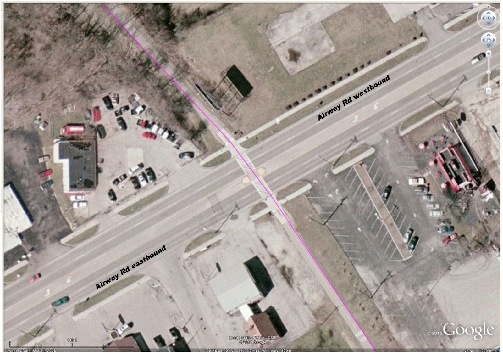
Bikeway crossing (magenta) at Airway Rd, Riverside OH
Then another pair of drivers exhibited their at-any-cost ownership of the road at the bikeway crossing at Airway. This crossing is well marked with pedestrian slashes embossed on the street, auto signs posted for the approaching two lanes of autos from each direction, in-path signage for the approaching bikeway users, and a pedestrian island placed to allow a pause in the crossing. As I approached the crossing from the north (top of image), the street was clear of traffic from the east, and two vehicles approached from as far away as Linh's Restaurant. —At about the location of the green car in the image.— I crossed the two westbound lanes, and saw neither of the two roadway users were slowing. So I stopped at the island. The near driver, of a pickup marked Extermital, sneered and flipped me off. Do I infer again some attitude of impatience—or dominance—from this driver?

No ego from me (for once) feels offence. No shift in mood. And my mood was heightened not more than a couple miles down the bikeway, at the corner of the DPL Executive Golf Course. My happy whistling startled three beautiful, strong deer who looked up from their grazing beside the bikeway. They glanced at each other, then scattered into the trees that line the bikeway. Four more deer inside the DPL compound galloped in the opposite direction toward the tree-lined creek.

At Woodbine, I saw Two-dog-Jason approaching the crossing from the south. Since I had to stop for a car, my crossing was slow. I introduced myself and Two-dog-Jason told me his name: Pat. It's been at least three years that we've seen each other on the bikeway during my morning commute. Finally there are real names for us to add to our hellos.

Central Park, New York City
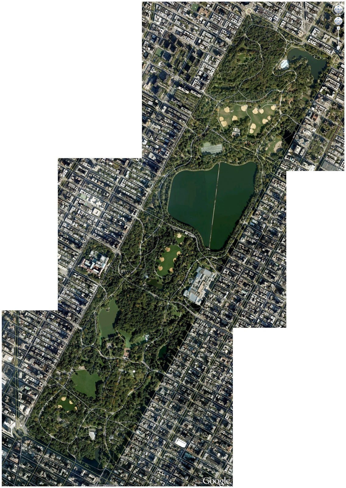
In New York City's Central Park another controversy is developing. In the hardcopy version, the article was titled "Neither Pedestrian Nor Auto." (It is otherwise titled in the online edition.) But the summarized assertion of the original title exhibits a basic misunderstanding of the position of the bicycle in the mix of transportation. Absolutely the bicycle is a vehicle. The cyclist is also a pedestrian—when a cyclist dismounts, the transformation is then complete. But nevertheless, all—motorist, cyclist, and pedestrian—must obey posted traffic signage. At issue for cyclists using Central Park are the questions of courtesy and obeying the hierarchy of trail usage. (In trail usage, cyclists must give right-of-way to pedestrians and horses; pedestrians must give right-of-way to horses; horses must give freedom-from-road-apples to everyone.)

From the few visits I have made to Central Park, it is not the best location for bicycle training. The number of strollers who also use the streets and paths that are closed off from vehicular traffic is too large for developing power, heart strength, stamina. The park is, though, well suited for the casual, pleasant Sunday ride with the family. Begging for attention is whether any convenient location exists on Manhattan Island for cyclists to train, free from the traffic snarls, exhaust, and stop-and-start progress of the streets.

Temperature: 37°F at 07:20, 29 to 39°F at 09:15
Precipitation: none
Winds: none
Clothing: Top with 4 layers (Lycra longsleeve undershirt, skinsuit, arm warmers, poly fleece vest, Lycra-wool jacket); Bottom with 2 layer (skinsuit, quilted tights); ankle socks. Quilted gloves. (Comfortable at first, but zipping down 3 of the top layers by the time I reached Woodbine. Moderate sweating in chest & back.)
Bike: Lotus fixed-gear
Time: 0:55:00 (approx.) for 11.86 miles
Bikeway users: 3 pedestrians, 4 dogs, 7 deer

07:50—departing from home.
08:xx—passing the zig-zag up from the Mad River Bikeway.
08:xx—passing the west gate to Eastwood Park.
08:xx—passing the trestle remains at Linden.
08:45—arriving at work. (No checkpoint times available.)

31 March 2011

Bike commute day 10, to work

As I rose to the top of the banks above the Mad River, which stretches from the Findlay Street bridge to the firemen's training yards at McFadden Avenue, I saw a white van on the adjacent stretch of Monument Avenue. His window was open, despite the below-freezing temperatures; his hand was up to his ear, indicating a split attention between driving and using his cellphone. I called out, "Get off the phone" loud enough that he glanced over at me. I smiled, which along with my nose was probably the only visible part of my face shrouded in a full-head stocking cap and smoked glasses. He nodded, smiled, and then resumed his phone conversation.
Bikeway (magenta) above the Mad River from the Findlay Street bridge to the firemen's training yards
March 2005 photo from Google Earth

It doesn't bother me greatly when as much as 25 yards separate the bikeway from the roadway, but inattentive drivers can be a real hazard on my route along residential streets in the first tenth of my commute and at the ten crossings once I've joined the bikeway. The Ohio legislature is due any day to vote on whether texting while driving is allowed or outlawed, which is outlawed in 30 states; but the legislature missed the mark many years ago in making it against the law to use a hand-held cellphone while driving, which is outlawed in eight states.

Of course, it is inattention of any sort that contributes to auto accidents ...and collisions with cyclists. If it were possible, could legislatures outlaw these activities while driving, which I have seen as a cause for a swerve or drift in a car's position in the road?
  • Lighting a cigarette
  • Eating
  • Tuning the radio
  • Changing a CD
  • Reading the newspaper
  • Consulting a map
  • Writing notes
  • Changing clothes
  • Talking animatedly
  • Reprimanding a child in the back seat
  • Reacting to spilled coffee in the lap

Temperature: 29°F at 07:30, 29 to 33°F at 09:15
Precipitation: none
Winds: none
Clothing: Top with 4 layers (Lycra longsleeve undershirt, skinsuit, arm warmers, poly fleece vest, Lycra-wool jacket); Bottom with 2 layer (skinsuit, quilted tights); ankle socks. Quilted gloves. (Comfortable; toes and fingers began to notice cold. Light sweating in chest & back.)
Bike: Trek 850
Time: 0:50:00 (approx.) for 11.86 miles
Bikeway users: 1 pedestrians, 6 deer, 1 cat

08:12—departing from home.
08:24—passing the zig-zag up from the Mad River Bikeway.
08:36—passing the west gate to Eastwood Park.
08:48—passing the trestle remains at Linden.
09:02—arriving at work.

29 March 2011

Bike commute day 9, to work

Notice: Today's entry is a Dear Diary entry that some readers might find embarrassing or even offensive. If so, read elsewhere today.

It's a ride like this one today that stresses how the things that might seem insignificant can affect the pleasure and efficiency of a ride. Soon after I started, even at turning the first corner, I knew that I was uncomfortable. I tried to shift my "junk" with a grab for it, but the quilted gloves I wore took no hold, and the quilted tights and skinsuit were too resistant to manipulating what was inside. Without even a bit of success, I kept on pedaling in hopes that everything would shift around as I continued on.

I tried again and again: grabbing occasionally, realigning myself on the seat, standing on the pedals, back down on the nose, trying another grab. Still the end was stuck between my leg and the abrading edge of the crotch padding. Then finally a bit of a change happened, to something less noticeable, more bearable.

But the easy unity of man and machine was elusive. Every two-dozen pedal strokes, the abrasion edged in again, then gradually shifted to some more relative comfort, only then to reiterate. My mind was on my body instead of on the road, the machine, and the dynamo that I should have been in the equation.

What could have been an opportunity for relief, a side trip to buy lottery tickets at a gas station near the bikeway, wasn't useful. I was off the bike, gloves off in the quick-shop area, and shifted the underlying skinsuit to fit in tighter to the crotch and bring the package up and out. Ah! Finally, a bit of comfort that the support brings! But by the time I returned to riding on the bike, the had skinsuit loosened, and my junk shifted again and settled into the same irritating position.

What many new cyclists don't take to heart is the advice that the cycling shorts are meant to be worn without underwear. There are tried-and-true reasons behind going commando.
  1. The pad, whether the older chamois or newer engineered fabrics, can absorb and wick away sweat or even water taken in from a rain storm. If moisture is not wicked away, it adds a chafing element to any movement between skin and shorts. 
  2. Cycling shorts are cut to limit the amount of hemmed fabric at the points of most contact. The seams, as small as possible, are along the perineal suture and at the outer sides of the hips. 
  3. The most recent saddles incorporate a hollow that matches the perineal suture, to further avoid irritation at the one seam in the saddle area.
  4. If underwear is worn, the hems along the leg openings and the bunching up of excess fabric all collect and hold sweat, which contributes to abrasion at every contact point with the seat.
  5. My dermatologist has advised using A+D Cream liberally in the crotch to give further prevention of chafing and moisture irritation. I've found this zinc oxide cream a great improvement over using chamois butters and other creams.
But my experience today shows that everything inside needs to be well positioned. So forgive that cyclist you see abruptly adjusting the family jewels before he swings a leg up and hops onto the saddle.

My times today belie the lowered efficiency. Three minutes additional time in the downhill first leg, but still I rode within the usual split times for the second and third legs.

Temperature: 29 to 31°F at 07:30
Precipitation: none
Winds: none to light
Clothing: Top with 4 layers=too toasty (longsleeve Lycra undershirt, skinsuit, fleece vest, arm warmers, wool-lycra jacket); Bottom with 2 layers=just right (skinsuit, quilted tights); ankle socks, quilted gloves.
Bike: Trek 850
Time: 1:00:00 (approx.) for 11.85 miles
Bikeway users: none others

08:24—departing from home.
08:41—passing the zig-zag up from the Mad River Bikeway.
08:52—passing the west gate to Eastwood Park.
09:06—passing the trestle remains at Linden. Side trip to buy lottery tickets.
09:24—arriving at  work.