Translate

Showing posts with label 39°F. Show all posts

25 February 2013

Ride to Taylorsville Dam

Monday, 25 February 2013

Bikeway (red) from Dayton
to Taylorsville Dam
Because tomorrow's weather forecast includes rain and sleet, I felt today's sunny skies beckoning. And I felt I had enough time to extend yesterday's trip all the way to Taylorsville Dam. On my way, I stopped at the closed steel bridge that had crossed to Johnson Station. I glimpsed momentary bits of a little community that forms a sub-suburb to Huber Heights. I climbed the serpentine bikeway to just underneath Highway 40, and descended to Taylorsville Reserve. At my turnaround, I read the National Trail Association's memorial board that describes Tadmore and Taylorsville. The gist of it: poor little Tadmore, once at the crossings of an important railway, a canal system, and the National Road, it was doomed to oblivion because of the advance of the highway system.

Butler township (left) and Wayne
township as illustrated in 1874
I've been taking this route as a sort of genealogical research project. My focus is the National Road, on which my great-grandparents Robert and Leopolinda Ohnsat traveled between 1877 and March 1878. Though the National Road was in greatest use from about 1840 through 1860, a family anecdote describes their trip by Conestoga wagon from Pittsburgh PA to Tipton KS. (Whether true is another matter, since the railway system was a well-developed and more-reliable means of travel by 1877.)

And the National Road passes just north of Dayton, crossing through Vandalia and Englewood. An 1875 map I have shows the National Road and a bridge at Tadmer, just east of Vandalia. (When I find one, I will add a map of Bethel township from Miami county.) There are several other intriguing points:
  • The Miami Canal that passes over the Miami River halfway between Johnson's Station and Tadmer
  • The little town of Orsville that would become known as Taylorsville within 50 years
  • The Dayton & Michigan Railroad that has a modern-day parallel that also passes underneath Taylorsville Dam
Butler and Wayne townships as
illustrated in 1838
Today, U.S. Highway 40 takes nearly the same route as the National Road. But not always, as Highway 40 drops 1.5 miles south to cross Taylorsville Dam. A 1938 map shows U.S. 40. (When I find one, I will add a map of Bethel township from Miami county.) The river crossing at Tadmor (with a slight name change) is still present in 1938, though it no longer exists. There are other notable changes:
  • The renamed Miami & Erie Canal no longer crosses the river
  • Taylorsville has some platted homesteads
  • The renamed Baltimore & Ohio Railroad follows nearly the same route
Perhaps this spring, I can trek through the park system and find remnants of the old road. In the meantime, I plan to ride the bikeways near the National Road where it drops 0.8 mile south to cross Englewood Dam at Englewood, at the west side of Butler township. These two diversions between the National Road and U.S. 40 are among the few. The next diversion west is at Knightstown-Raysville-Ogden IN, the next east is at Cambridge OH (east of Zanesville).

Ride conditions
Temperature: 39 to 44°F at 16:24 to 18:30
Precipitation: none
Winds: 10 to 15 mph from the east
Clothing: Skinsuit, cotton undershirt, longsleeve undershirt, ankle socks, tights, light jacket, full-finger gloves
Bike: Lotus Legend fixed 48x16
Time: 02:06 for 26.0 miles
Bikeway users: 2 cyclists, 8 pedestrians, 3 dogs

24 February 2013

Sunday before the Oscars

Sunday, 24 February 2013

A chilly ride up into Butler township on the Great Miami Bikeway. I went a bit north of the underpass of Needmore, and explored the short roads that intersect the path at Birch: to the right to find a small, neighborhood of run-down homes near the river, then to the left past a mobile home park and up to the intersection with Wagner-Ford Road.

I wondered if this area was once Johnson's Station that was east of Chambersburg (as known in 1875, map shown). But looking again at the map, I think my ride actually missed reaching Butler township. Dayton township abuts Butler township at its southern edge, and Wayne township reaches a bit more north, on the east side of the river. Just south of this three-township junction, in a swansneck of the river is the little settlement I explored.

Ride conditions
Temperature: 39°F at 16:40
Precipitation: none
Winds: calm to 5 to 8 mph from the southwest
Clothing: Skinsuit, longsleeve undershirt, contton undershirt, ankle socks, tights, light jacket, full-finger gloves
Bike: Lotus Legend fixed 48x16
Time: 01:25 for 20.16 miles
Bikeway users: 5 cyclists, 3 pedestrians, 2 dogs

25 October 2011

Bike-commute day 95—to work

Tuesday, 25 October 2011

Going to work today is the second half of my commuting day, since I drove to work yesterday with my bike in the van and then rode home. This part of the year always has an alternation of drive-bike-bike-drive since the daylight is so short. And tonight, during the drive, I'll stop at Cardinal Fitness to get in a bit of weight training. The leg routine is due tonight.

Today was the first time I broke out the quilted tights. Since my breath was visible when I took Howard out, I thought that a heavier layer would be good, even with the temperatures above freezing. At some midpoint of the ride, I decided that I was overdressed. I had begun to heat up, even though my effort was not too great. I've got to learn once again when the added layers are necessary, when they're too much.

Ride conditions
Temperature: 34 to 41°F at 07:40
Precipitation: none
Winds: calm to 5 mph from the south 
Clothing: Skinsuit, longsleeve undershirt, quilted tights, Gore-tex jacket, ankle socks, full-finger gloves
Bike: Lotus Legend fixed gear
Time: 00:44:15 for 11.94 miles
Heart rate: 138 bpm HRave, 153 bpm HRmax
Bikeway users: 1 cyclist, 6 pedestrians, 2 dogs
Playback of the ride

05 May 2011

Bike-commute day 19—to work

Recently the City of Dayton released its 2025 Bicycle Action Plan, and it asked for comments to be sent to Andrew Rodney. Among my suggestions, I asked that the city establish alternative, designated routes that are parallel to the bikeways and can be used during river flooding or bridge construction. I would hope, in implementing this suggestion, that the street department would install facilities that make the alternate routes safer than they already are.

For the most part, these routes already exist, though they are not designated or in much use by cyclists. For example, these parallel routes already exist near the bikeway that typically is flooded during high water:
  • East Monument Avenue parallels the Mad River Bikeway from Irwin Street west to North Patterson Boulevard.
  • The Riverwalk and a gravel path parallel the Great Miami River from North Patterson Boulevard to the Monument Avenue Bridge.
  • An unnamed delivery street parallels the Great Miami River south from Washington Street to Veterans' Park near Stewart Street.
  • East River Road in Moraine parallels the Great Miami River south from Carillon Boulevard to the point where the river-level bikeway rises to join East River Road.
  • North Alex Road parallels the Great Miami River in West Carrollton.
  • North Miami Street parallels the Great Miami River in Miamisburg.
Not all of these are contiguous, and some construction is needed to make them so. But the existing routing needs little more than a marking system or curbing system that makes sharing the road safe.


My energy level on today's ride was fairly low. The 705 device worked well until 38:08 into the ride, when the 705 went to autopause for no reason. (I remember that just prior to the shift to autopause, a loose twig got picked up in the rear wheel, at the cadence sensor, and that I looked town to check that it was clearing from the wheel.) I lost data from just south of Linden Avenue through just south of Woodbine. I turned off the device, waited 10 seconds, turned it on, and waited for acquisition of satellite information before resuming. This restart caused an additional lap time (split 4).

Ride conditions
Temperature: 34 to 41°F at 06:45
Precipitation: none
Winds: calm to 5 mph from the east
Clothing: 2-layer top, 2-layer bottom; ankle socks. Full-finger gloves.
Bike: Trek 850
Time: between 00:46:25 and 0:57:00 for 12.00 miles
Heart rate:124 bpm average, 142 bpm maximum
Bikeway users: 2 pedestrians, 2 cyclists
Here is a playback of the ride. 4th Garmin day.

Note about the illustration
The line drawings were published online and captured by me during the playback. The video provides stills from The Art of Frank Patterson by Horace F. Button, which was published 1952 by Temple Press, Ltd.

14 April 2011

Bike-commute day 15—to work
Time for the Spring tune-up

I rode the least likely bike for good times today, so I can bring it to Kettering Bike Shop for a minor tune-up. I've been planning a biking trip for Easter weekend: drive to Mammoth Cave KY and do some road biking on Good Friday, take the Grand Avenue tour and meet some members of the Bowling Green Bicycle Adventures for riding the Sal Hollow Trail on Saturday, and take the Introduction to Caving and perhaps some road biking on Easter Sunday, then drive back to Dayton late that day. And this bike, meant for stump-jumping and challenging trails, needs some alignment of its shifting. The small sprocket in front doesn't keep the chain well, and sometimes an energetic shift will throw the chain off the big sprocket. In the cassette cogs, there is a lot of sloppy action when the chain is forced to cross from the inner cogs to the outer front sprocket.

I've tried adjusting the shift movement myself in years past, but it is a frustrating chore if you have neither patience nor practice. The better alternative is to have a reliable bike shop do this for you. Typically the cost is under $35. You can find several websites that guide you in adjusting the shifters and brakes—almost too many offer their advice. Here are some sites for adjusting the shifters, and each has a connecting link to information for adjusting brakes.
The sloppy shifting comes from a couple sources. The most common source is the gradual stretch that shift cables naturally go through for the first few months of use. This stretching is recognized by bike shops, who encourage you to return for a tightening a month or so after receiving new cables. Another source of sloppy shifting comes near the end of a cable's useful life, when the metal breaks down, becomes brittle, or frays at friction points. In addition to the cable, the mechanical assemblies that hold the cable to a shifter, derailleur, or brake can loosen or fail. Your bike mechanic will notice and repair the developing failures of cables or attachments, but the cost of materials may increase the basic price for a cable tune-up.

Because commuting by bike from March through October can total almost 3000 miles, I usually take each bike in for a tune-up once a year.

Housekeeping notes
  • Creekside Trail had small amounts of broken glass at several locations between Fairpark Avenue and Airway Road.
  • Creekside Trail had a fallen tree across the path about 0.4 mile north of the trestle ruins.
  • Iron Horse Trail had broken glass about 0.1 mile north of the pedestrian access at Arcadia Avenue.
  • Iron Horse Trail had broken glass at the bridge as the bikeway joins Spaulding Road.
Ride conditions
Temperature: 37 to 43°F at 07:10, 51 to 56°F at 09:15
Precipitation: none
Winds: calm
Clothing: 3-layer top, 2-layer bottom; ankle socks. Goretex full-finger gloves.
Bike: Mongoose MGX D40
Time: 0:56:00 (approx.) for 11.86 miles
Bikeway users: 1 cyclist, 2 pedestrians, 1 dog

08:16—departing from home.
08:29—passing the zig-zag down to the Mad River Bikeway.
08:41—passing the west gate to Eastwood Park.
08:56—passing the trestle remains at Linden.
09:12—arriving at work.

13 April 2011

Bike-commute day 14—to work
The 7-headed Hydra

I'm back on the bikeways after a couple of rainy days. Sunday this week was clear and warm, even into the 80s, and the start of warmer days reminds me of the need for hydration.

The experience of competitive athletes and their trainers has revealed the easiest way to improve training and racing performance: maintain sufficient fluid levels in your body. Most people function well enough with a bit of dehydration, but even slight dehydration can be a problem for the active person. And it gets worse, much worse, as the daily temperatures exceed 80°F.

If you've been cycling during the early Spring, your body has been using the generated heat from exercise to keep your extremities and core warm. Typically you'll sweat little in cold weather. As the air temperatures warm, though, your body shifts from warming to cooling. Sweating increases, and the sweat works to cool the body by evaporation. Athletes are able to sweat sooner and more profusely. But sweat depends on a proper balance of hydration, and it works even better with a tip toward overhydration.

Body fluid levels are important for smooth joint movement and efficient muscle contraction-release also. With dehydration, most of your tissues shrink slightly, much like a drying sponge. Fluids aren't available in enough quantity to lubricate the cell-to-cell interaction, and your strength and stamina both suffer.

Go into each workout—or each commute—with a reserve of body fluid levels. Your performance and cooling ability will benefit greatly.
  • Drink fluids throughout the day, including with each meal or snack. Also sip about 20 oz. of water in the evening to replenish your levels through the off-time.
  • Weigh yourself immediately before a ride of 45 minutes or longer, to help measure the body fluids lost during exercise.
  • While cycling, drink 12 to 16 oz. each half hour. Alternate between a bottle of water and a bottle of sports drink to replenish electrolytes. 
  • Weigh yourself at the end of the ride, to find the difference in weight before and after the ride. Take in 1.5 times that difference in fluid oz. of water. (Each pound lost equals 24 fluid oz. water to replenish.)
Some of this information comes from advice provided by Chris Carmichael of Carmichael Training Systems.
Temperature: 35 to 41°F at 06:35, 51 to 55°F at 09:15
Precipitation: none
Winds: calm
Clothing: 3-layer top, 2-layer bottom; ankle socks. Goretex full-finger gloves.
Bike: Trek 850
Time: 0:49:00 (approx.) for 11.86 miles
Bikeway users: 2 cyclists, 4 pedestrians, 1 dog

08:05—departing from home.
08:19—passing the zig-zag down to the Mad River Bikeway.
08:29—passing the west gate to Eastwood Park.
08:42—passing the trestle remains at Linden.
08:54—arriving at work.

05 April 2011

Bike-commute day 11—to work
How not to smooth auto-bike traffic

The rains stopped last evening, and the roads were dry in the morning. But as I crossed the Monument Street bridge, shielding my eyes from the bright sunshine, I saw the river was overflowing to the bikeway. Since I was on my Lotus fixed-gear, taking the gravel concourse above the river was out of the question, and I took the sidewalk—slowly, careful of two pedestrians and one with a vacuum cleaner in tow—against the flow of traffic in the street. At the ziz-zag down near the Green Bridge, I saw that the Mad River was living up to its name: an even higher and stronger flow was coursing into the Miami, and the bikeway was flooded at least to the railroad trestle near Valley Street.

So I took Monument Avenue through the light manufacturing area.

One pickup driver did everything possible to thwart his easy entrance to Monument from a service yard. As I rode along Monument going east, a pickup driver pulled to the street from a Rumpke service yard, stopped, looked both ways, apparently saw me, and released his brakes enough to coast an additional 3 feet. I interpreted his coasting as impatience and potentially a sign that he had not seen me approaching. I slowed a lot, expecting him to pull into the street. He stopped again. It was clear he had seen me, and he had just anticipated moving into the street prematurely. His impatience (my inference here) resulted in a few more seconds of stopping before his turn onto Monument, and (I infer again) increased what impatience he already felt.

Bikeway crossing (magenta) at Airway Rd, Riverside OH
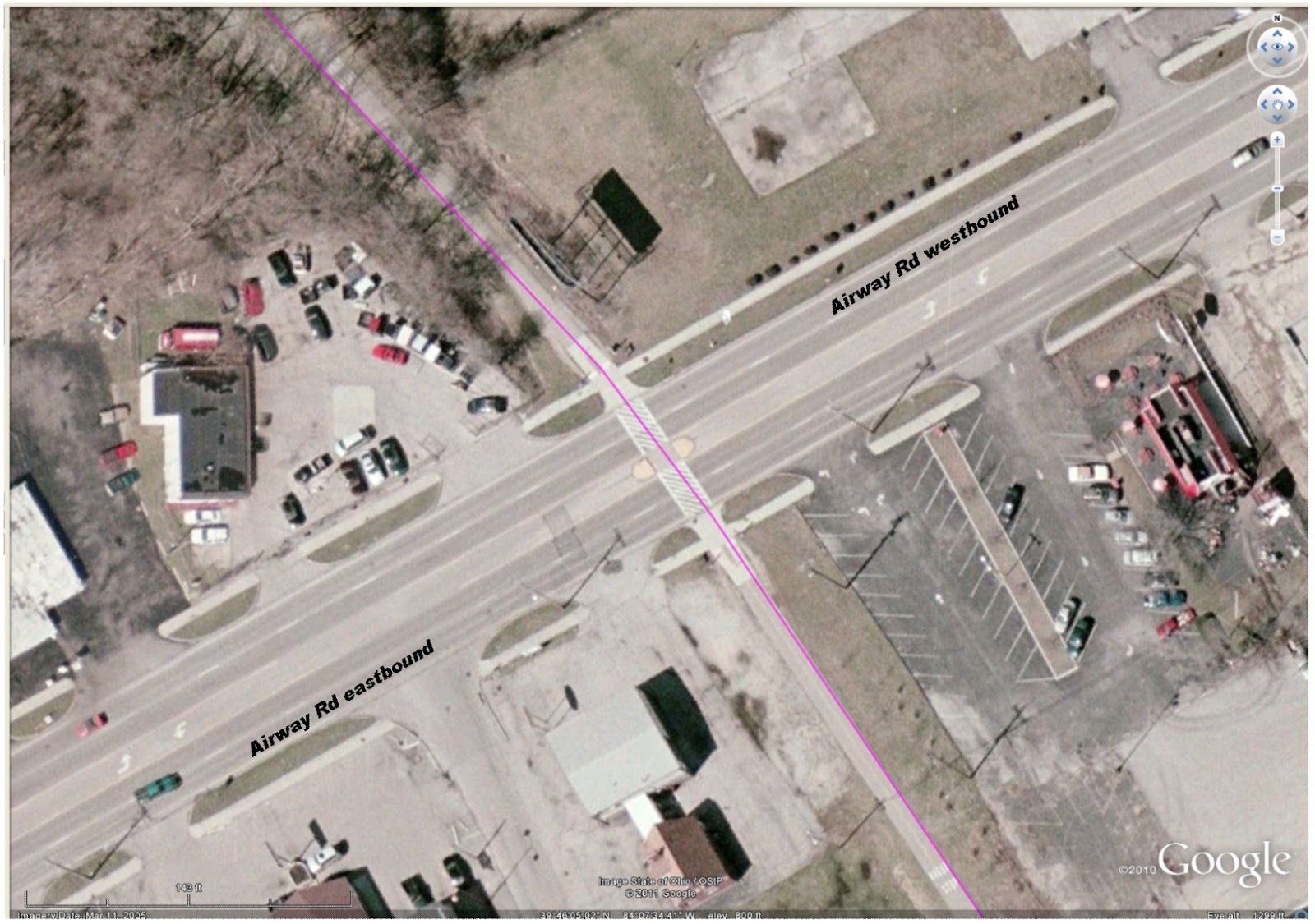
Then another pair of drivers exhibited their at-any-cost ownership of the road at the bikeway crossing at Airway. This crossing is well marked with pedestrian slashes embossed on the street, auto signs posted for the approaching two lanes of autos from each direction, in-path signage for the approaching bikeway users, and a pedestrian island placed to allow a pause in the crossing. As I approached the crossing from the north (top of image), the street was clear of traffic from the east, and two vehicles approached from as far away as Linh's Restaurant. —At about the location of the green car in the image.— I crossed the two westbound lanes, and saw neither of the two roadway users were slowing. So I stopped at the island. The near driver, of a pickup marked Extermital, sneered and flipped me off. Do I infer again some attitude of impatience—or dominance—from this driver?

No ego from me (for once) feels offence. No shift in mood. And my mood was heightened not more than a couple miles down the bikeway, at the corner of the DPL Executive Golf Course. My happy whistling startled three beautiful, strong deer who looked up from their grazing beside the bikeway. They glanced at each other, then scattered into the trees that line the bikeway. Four more deer inside the DPL compound galloped in the opposite direction toward the tree-lined creek.

At Woodbine, I saw Two-dog-Jason approaching the crossing from the south. Since I had to stop for a car, my crossing was slow. I introduced myself and Two-dog-Jason told me his name: Pat. It's been at least three years that we've seen each other on the bikeway during my morning commute. Finally there are real names for us to add to our hellos.

Central Park, New York City
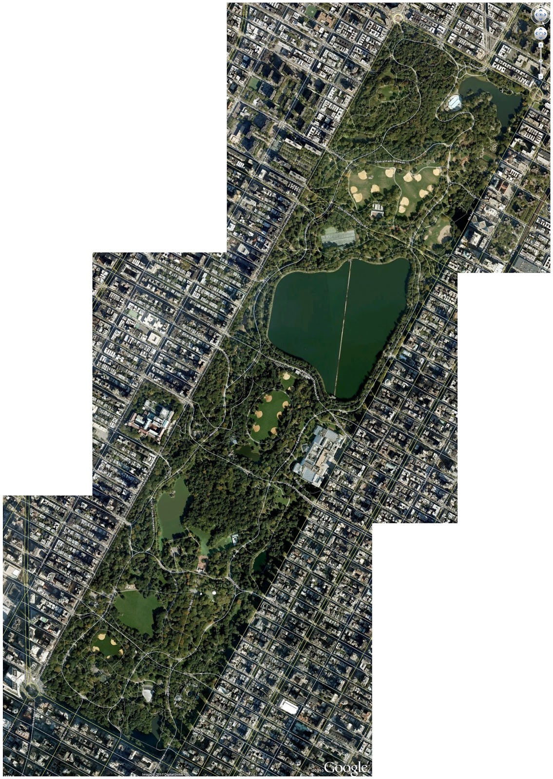
In New York City's Central Park another controversy is developing. In the hardcopy version, the article was titled "Neither Pedestrian Nor Auto." (It is otherwise titled in the online edition.) But the summarized assertion of the original title exhibits a basic misunderstanding of the position of the bicycle in the mix of transportation. Absolutely the bicycle is a vehicle. The cyclist is also a pedestrian—when a cyclist dismounts, the transformation is then complete. But nevertheless, all—motorist, cyclist, and pedestrian—must obey posted traffic signage. At issue for cyclists using Central Park are the questions of courtesy and obeying the hierarchy of trail usage. (In trail usage, cyclists must give right-of-way to pedestrians and horses; pedestrians must give right-of-way to horses; horses must give freedom-from-road-apples to everyone.)

From the few visits I have made to Central Park, it is not the best location for bicycle training. The number of strollers who also use the streets and paths that are closed off from vehicular traffic is too large for developing power, heart strength, stamina. The park is, though, well suited for the casual, pleasant Sunday ride with the family. Begging for attention is whether any convenient location exists on Manhattan Island for cyclists to train, free from the traffic snarls, exhaust, and stop-and-start progress of the streets.

Temperature: 37°F at 07:20, 29 to 39°F at 09:15
Precipitation: none
Winds: none
Clothing: Top with 4 layers (Lycra longsleeve undershirt, skinsuit, arm warmers, poly fleece vest, Lycra-wool jacket); Bottom with 2 layer (skinsuit, quilted tights); ankle socks. Quilted gloves. (Comfortable at first, but zipping down 3 of the top layers by the time I reached Woodbine. Moderate sweating in chest & back.)
Bike: Lotus fixed-gear
Time: 0:55:00 (approx.) for 11.86 miles
Bikeway users: 3 pedestrians, 4 dogs, 7 deer

07:50—departing from home.
08:xx—passing the zig-zag up from the Mad River Bikeway.
08:xx—passing the west gate to Eastwood Park.
08:xx—passing the trestle remains at Linden.
08:45—arriving at work. (No checkpoint times available.)

24 March 2011

Bike commute day 7, heading home

Gary C. was out the office door at the same time I was this evening, and he asked me if I was dressed warmly enough. My three layers don't look too bulky, with every layer a tight-fitting, relatively thin fabric. I assured him that whatever the weight of the fabric, I would be warm enough, given that the cycling itself provides some heat from inside.

He also noted how the fluorescent yellow of my jacket sleeves make me much more visible, and I agreed that it helps a lot in the early evening of such a gray day. On my way, I wondered why so many cycling outer layers are black or dark. It seems that all tights and quilteds should have at least a reflective stripe, piped on the outside seams, much like the satin ribbon on tuxedo slacks. Similarly for jackets and arm warmers, some reflective areas should be a standard part of the design.

Temperature: 37-39°F at 19:00
Precipitation: none
Winds: calm to 5 mph from the west
Clothing: 3-layer top; 2-layer bottom, closed-finger gloves.
Time: 0:51:00 (approx.) for 12.5 miles
Bikeway users: 0 cyclists, 9 pedestrians

18:33—depart from work.
18:46—trestle remains at Linden.
18:58—west gate to Eastwood Park.
19:09—passing the zig-zag up from the Mad River Bikeway.
19:24—arrive home.

17 March 2011

Bike commute day 5, to work—Scents and Glass

Temperature: 39°F at 07:30, 43°F at 07:55
Precipitation: none
Winds: none to light
Clothing: Top with 2 layers (Lycra longsleeve undershirt, skinsuit); Bottom with 1 layer (skinsuit); ankle socks. Open-finger gloves. (Cool, almost comfortable; fingers too cold. A higher speed didn't really help.)
Bike: Trek 850
Time: 0:50:00 (approx.) for 12.5 miles
Bikeway users: 2 pedestrians, 2 cyclists, 4 tree trimmers


First light at 07:18, enough light for cycling at 07:38, official sunrise at 07:45, real start at 08:00.


08:20—departing from home. The Miami River had receded from the bikeway, but it was still lapping at the bikeway edge, all the way from below the YMCA through to Riverscape. Some of the bikeway there still had drying mud, but nothing slippery.

08:33—passing the zig-zag up from the Mad River Bikeway. What an envigorating ride this morning! As I passed along the Mad River, I smelled fresh lumber from Requarth's, mildly sour milk from Rumpke's, burnt carbon from Dayton Forging & Heat, freshly budding Saint Anne's Lace, and fresh mud from the stream outside of Eastwood Park.

08:43—passing the west gate to Eastwood Park. The smells of the second leg gave way to offensive odors of paint spraying south of Fair Park Avenue. At least the supreme offense of Multi-Service is no more! I noted that two separate spills of glass were on the east-west section of bikeway north of Miami Valley Manufacturing & Assembly, and a third spill was about a block north of the Airway crossing, right at the entrance to the bootleg BMX path. South of Airway, I rode through local aromas again: hot frying oil behind Old Hickory Barbecue and the fetidness of the glades west of the DPL executive park.

08:56—passing the trestle remains at Linden. Before I could cross Woodbine, I had to walk my bike around a truck in the bikeway. The wood chipper behind the truck was redolent of freshly chewed wood, fed by the DPL crews who were giving a tonsure to the trees underneath the electrical lines. Then after crossing Woodman, I smelled the composted mulch—almost like ensilage from my farmboy youth, and finally the soapy-sulfide smell from the Montgomery County Eastern Waste Treatment Plant.

09:10—arriving at  work.

07 March 2011

Bike commute day 2, return home

Temperatures: 39°F at 17:00, 37°F at 18:15
Clothing: Top with 2 layers, with closely-woven wool-acrylic cycling jacket included; Lycra tights; ankle socks. Thinsulate gloves. (Cool, just still comfortable. A higher speed helped.)
Time: 0:45xx for 12.5 miles

17:45—depart from work, with a bad break of just getting to a red light at Research. Only a short wait for traffic at Woodman. A family of 3 walked toward me, and then two cyclists.

17:57—trestle remains at Linden. There was still a faint smell of skunk north of Burkhardt, but much less than the perfume there in the morning. Two pedestrians at the Airway crossing helped stop traffic and allow a quicker passage, and a motorist in the west-bound lane also stopped for my crossing. How nice. Maybe this year will be one of courtesy. I whistled at a runner as I approached the Smithville crossing, and asked if he was cold with the bare legs. "Yup" was his reply.

18:08—west gate to Eastwood Park. I pushed a bit harder through the park to make sure that the clock didn't flow past another minute. I felt pretty good about my time so far, and still nothing à bout de soufle about my work. The minute didn't click to 09 until I had crossed the creek and crested the rise to the old railway path, so lots of time to spare..

18:18—passing the zig-zag up from the Mad River Bikeway, as I travel on Monument Avenue. I had a red light at Webster, and was able to ride through all of downtown without another, until I got to Forest-Riverside. Even then, I slowed a bit on the bridge, and timed myself to a green light by the time I got to the intersection. The climb up Grafton hill was a bit hard, since I was under fatigue from the harder ride through the city.

The crossing at Salem was against a red light, though I stopped long enough to see that no traffic on Salem was closer than a couple blocks. I pressed hard up the Bryn Mawr hill, shifting down once to get a higher cadence.

18:30—arrive home, with some energy to spare.

Now it's time, after finishing this post, to shower quickly and make it to the dinner meeting for the Dayton Bicylce Adventures Online Cyclists Group.